


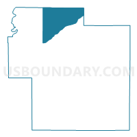
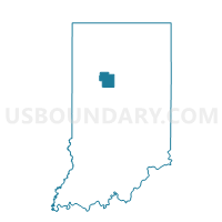
ADAMS, Carroll County, Indiana
About
Outline

Summary
| Unique Area Identifier | 576513 |
| Name | ADAMS |
| County | Carroll County |
| State | Indiana |
| Area (square miles) | 25.99 |
| Land Area (square miles) | 25.67 |
| Water Area (square miles) | 0.32 |
| % of Land Area | 98.75 |
| % of Water Area | 1.25 |
| Latitude of the Internal Point | 40.70359460 |
| Longtitude of the Internal Point | -86.61085580 |
Maps

Graphs
Select a template below for downloading or customizing gragh for ADAMS, Carroll County, Indiana


Neighbors
Neighoring Voting District (by Name) Neighboring Voting District on the Map
- 18 CLINTON, Cass County, IN
- 24 JEFFERSON, Cass County, IN
- DEER CREEK I, Carroll County, IN
- JACKSON 1, White County, IN
- JEFFERSON I, Carroll County, IN
- JEFFERSON II, Carroll County, IN
- LIBERTY, Carroll County, IN
- LINCOLN 1, White County, IN
- ROCK CREEK, Carroll County, IN
- TIPPECANOE I, Carroll County, IN
Top 10 Neighboring County Subdivision (by Population) Neighboring County Subdivision on the Map
- Deer Creek township, Carroll County, IN (4,571)
- Tippecanoe township, Carroll County, IN (2,341)
- Jefferson township, Carroll County, IN (2,162)
- Jefferson township, Cass County, IN (1,452)
- Clinton township, Cass County, IN (816)
- Jackson township, White County, IN (655)
- Lincoln township, White County, IN (638)
- Adams township, Carroll County, IN (516)
- Rock Creek township, Carroll County, IN (475)
- Liberty township, Carroll County, IN (440)
Top 10 Neighboring Place (by Population) Neighboring Place on the Map
Top 10 Neighboring Unified School District (by Population) Neighboring Unified School District on the Map
- Logansport Community School Corporation, IN (24,000)
- Twin Lakes School Corporation, IN (14,685)
- Delphi Community School Corporation, IN (9,651)
- Pioneer Regional School Corporation, IN (5,196)
Top 10 Neighboring State Legislative District Lower Chamber (by Population) Neighboring State Legislative District Lower Chamber on the Map
Top 10 Neighboring State Legislative District Upper Chamber (by Population) Neighboring State Legislative District Upper Chamber on the Map
Top 10 Neighboring 111th Congressional District (by Population) Neighboring 111th Congressional District on the Map
Top 10 Neighboring Census Tract (by Population) Neighboring Census Tract on the Map
- Census Tract 9518, Cass County, IN (3,972)
- Census Tract 9511, Cass County, IN (3,065)
- Census Tract 9593, Carroll County, IN (3,023)
- Census Tract 9587, White County, IN (2,636)
- Census Tract 9594, Carroll County, IN (2,592)